 |
Florida Administrative Code (Last Updated: April 18, 2024) |
 |
68. Fish and Wildlife Conservation Commission |
|
68D. Vessel Registration and Boating Safety |
|
68D-24. Boating Restricted Areas |
1(1) For the purpose of regulating speed and operation of vessel traffic on 14and adjacent to the Florida Intracoastal Waterway in Broward County, Florida, the following year-round boating restricted areas are established. The boating restricted areas exclude all associated tributaries, creeks, canals, backwaters, channels, boat basins and other waterways unless otherwise designated or specifically described for inclusion:
58(a)1. Hillsboro Boulevard Bridge – An Idle Speed No Wake zone from shoreline to shoreline, in and adjacent to the Florida Intracoastal Waterway, bounded on the north by a line drawn perpendicular to the centerline of the Florida Intracoastal Waterway 750 feet north of the Hillsboro Boulevard Bridge and bounded on the south by a line drawn perpendicular to the centerline of the Florida Intracoastal Waterway 800 feet south of said bridge as depicted in drawing A.
1352. Hillsboro Inlet Zones –
140a. An Idle Speed No Wake zone 147from shoreline to shoreline, 151in and adjacent to the Florida Intracoastal Waterway, bounded on the north by a line drawn perpendicular to the centerline of the Florida Intracoastal Waterway 100 feet north of 180latitude 26° 17.339' North, longitude 80° 4.842' West (approximately located at Channel Marker “68”), 194and on the south by a line drawn perpendicular to the centerline of the Florida Intracoastal Waterway 1,050 feet southwest of the intersection of the centerline of the Hillsboro Inlet channel and the centerline of the Florida Intracoastal Waterway, as depicted in drawing B.
239b. A Slow Speed Minimum Wake zone 246from shoreline to shoreline, 250in and adjacent to the Florida Intracoastal Waterway, and including all waters of the Hillsboro Inlet, bounded on the northwest by a line drawn from headland to headland across the northwestern end of the Hillsboro Inlet at its confluence with the Florida Intracoastal Waterway, and on the southeast by a line drawn perpendicular to the centerline of the inlet channel 150 feet northwest of the seaward extremities of the Hillsboro Inlet jetties, as depicted in drawing B.
327c. A Slow Speed Minimum Wake zone from shoreline to shoreline, in and adjacent to the Florida Intracoastal Waterway, bounded on the north by a line drawn perpendicular to the centerline of the Florida Intracoastal Waterway 1,050 feet south of the intersection of the centerline of the Hillsboro Inlet channel and the centerline of the Florida Intracoastal Waterway and on the south by a line drawn perpendicular to the centerline of the Florida Intracoastal Waterway 1,425 feet north of the North East 14th Street Bridge in Pompano Beach, as depicted in drawing B.
4223. North East 14th Street Bridge – An Idle Speed No Wake zone from 436shoreline to shoreline, 439in and adjacent to the Florida Intracoastal Waterway, 447bounded on the north by a line drawn perpendicular to the centerline of the Florida Intracoastal Waterway 1,425 feet north of the North East 14th Street Bridge in Pompano Beach and on the south by a line drawn 486perpendicular to the centerline of the Florida Intracoastal Waterway 300 feet south of said bridge, as depicted in drawing B.
5064. Atlantic Boulevard Bridge – An Idle Speed No Wake zone from shoreline to shoreline, in and adjacent to the Florida Intracoastal Waterway, bounded on the north by a line drawn perpendicular to the centerline of the waterway 1,350 feet north of the Atlantic 551Boulevard Bridge and bounded on the south by a line drawn perpendicular to the centerline of the 568Florida Intracoastal Waterway 571500 feet south of said bridge, as depicted in drawing C.
5825. East Commercial Boulevard Bridge – An Idle Speed No Wake zone from shoreline to shoreline, in and adjacent to the Florida Intracoastal Waterway, bounded on the north by a line drawn perpendicular to the centerline of the Florida Intracoastal Waterway 750 feet north of the East Commercial Boulevard Bridge and bounded on the south by a line drawn perpendicular to the centerline of the Florida Intracoastal Waterway 700 feet south of said bridge, as depicted in drawing D.
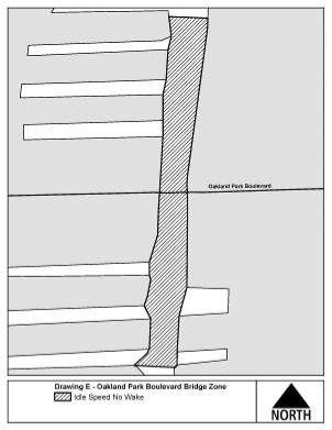
6616. Oakland 663Park Boulevard Bridge – An Idle Speed No Wake zone from shoreline to shoreline, in and adjacent to the Florida Intracoastal Waterway, and extending 1,500 feet north and south of the Oakland Park Boulevard 698Bridge, as depicted in drawing E.
7047. Sunrise Boulevard Bridge –
709a. An Idle Speed No Wake zone from shoreline to shoreline, in and adjacent to the Florida Intracoastal Waterway, from a line drawn perpendicular to the centerline of the 738Florida Intracoastal Waterway 7412,250 feet north of the Sunrise Boulevard Bridge to a line drawn perpendicular to the centerline of the 760Florida Intracoastal Waterway 7631,500 feet south of said bridge, as depicted in drawing F.
775b. A Slow Speed Minimum Wake zone to be in effect year787‑788round on Saturdays, Sundays and holidays as defined in Rule 68D799‑80024.002, F.A.C., from shoreline to shoreline, in and adjacent to the Florida Intracoastal Waterway, from a line drawn perpendicular to the centerline of the 824Florida Intracoastal Waterway 8271,500 feet south of the Sunrise Boulevard Bridge to a line drawn perpendicular to the centerline of the 846Florida Intracoastal Waterway 8491,500 feet north of the East Las Olas Bridge, as depicted in drawing F.
8648. East Las Olas Bridge – An Idle Speed No Wake zone from shoreline to shoreline, in and adjacent to the Florida Intracoastal Waterway, from a line drawn perpendicular to the centerline of the 898Florida Intracoastal Waterway 9011,500 feet north of the East Las Olas Bridge to a line drawn perpendicular to the centerline of the 921Florida Intracoastal Waterway 9243,300 feet south of said bridge, as depicted in drawing F.
9369. Stranahan River – A Slow Speed Minimum Wake zone from shoreline to shoreline, in and adjacent to the Florida Intracoastal Waterway, from a line drawn perpendicular to the centerline of the 968Florida Intracoastal Waterway 9713,300 feet south of the East Las Olas Bridge to a line drawn perpendicular to the centerline of the 991Florida Intracoastal Waterway 9941,500 feet north of the 17th Street Causeway Bridge, as depicted in drawing G.
100910. 17th Street Causeway Bridge – An Idle Speed No Wake zone from shoreline to shoreline, in and adjacent to the Florida Intracoastal Waterway, from a line drawn perpendicular to the centerline of the 1043Florida Intracoastal Waterway 10461,500 feet north of the 17th Street Causeway Bridge to a line drawn perpendicular to the centerline of the 1066Florida Intracoastal Waterway 1069800 feet south of said bridge, as depicted in drawing G.
108011. Dania Beach Boulevard Bridge – An Idle Speed No Wake zone from shoreline to shoreline, in and adjacent to the Florida Intracoastal Waterway, bounded on the north by a line drawn perpendicular to the centerline of the Florida Intracoastal Waterway 850 feet north of the Dania Beach Boulevard Bridge and bounded on the south by a line drawn perpendicular to the centerline of the Florida Intracoastal Waterway 1,940 feet south of said bridge, as depicted in drawing H.
116012. Sheridan Street Bridge – A Slow Speed Minimum Wake zone from shoreline to shoreline, in and adjacent to the Florida Intracoastal Waterway, bounded on the north by a line drawn perpendicular to the centerline of the Florida Intracoastal Waterway, 850 feet north of the Sheridan Street Bridge and bounded on the south by a line drawn perpendicular to the centerline of the Florida Intracoastal Waterway 750 feet south of said bridge, as depicted in drawing I.
123713. Hollywood Boulevard Bridge – An Idle Speed No Wake zone from shoreline to shoreline, in and adjacent to the Florida Intracoastal Waterway, bounded on the north by a line drawn perpendicular to the centerline of the Florida Intracoastal Waterway 2,570 feet south of the Sheridan Street Bridge and bounded on the south by a line drawn perpendicular to the centerline of the Florida Intracoastal Waterway 740 feet south of the Hollywood Boulevard Bridge, as depicted in drawing J.
131714. Hallandale Beach Boulevard Zones –
1323a. An Idle Speed No Wake zone from shoreline to shoreline, in and adjacent to the Florida Intracoastal Waterway, bounded on the north by a line drawn perpendicular to the centerline of the Florida Intracoastal Waterway 2,800 feet north of the Hallandale Beach Boulevard Bridge and bounded on the south by a line drawn perpendicular to the centerline of the Florida Intracoastal Waterway 1,325 feet north of said bridge, as depicted in drawing K.
1399b. A Slow Speed Minimum Wake zone from shoreline to shoreline, in and adjacent to the Florida Intracoastal Waterway, bounded on the north by a line drawn perpendicular to the centerline of the Florida Intracoastal Waterway 300 feet north of the Hallandale Beach Boulevard Bridge and bounded on the south by a line drawn perpendicular to the centerline of the Florida Intracoastal Waterway 400 feet south of said bridge, as depicted in drawing K.
1473c. A Slow Speed Minimum Wake zone from shoreline to shoreline, in and adjacent to the Florida Intracoastal Waterway, bounded on the north by a line drawn perpendicular to the centerline of the Florida Intracoastal Waterway 400 feet south of the Hallandale Beach Boulevard Bridge and bounded on the south by a line drawn perpendicular to the centerline of the Florida Intracoastal Waterway 1536at the Dade/Broward County line, 1541as depicted in drawing K.
1546(b) Thirty (30) miles per hour/fifteen inch (15"1554) wake zone –
15581. This paragraph applies to all waters of the New River Canal and the Florida Intracoastal Waterway within Broward County.
15782. Except where other speed limits or operation restrictions have been lawfully established, the maximum speed on these waters is thirty (30) miles per hour.
1603a. Any person who operates a vessel in excess of the thirty (30) miles per hour maximum speed limit is guilty of a noncriminal infraction, punishable by a civil penalty. The amount of the civil penalty shall be computed in accordance with the provisions pertaining to penalties for unlawful speed under Section 1655318.18(3), F.S.
1657b. For the purposes of enforcement of this subparagraph, law enforcement officers may use aircraft, vessels, manual or electronic timing devices, or radar. If radar is used, the provisions of Section 1688316.1906, F.S., 1690shall be complied with.
1694c. This subparagraph shall not be interpreted to mean that thirty (30) miles per hour is a safe speed for all vessels under all circumstances. Inland Navigation Rule 6, as adopted pursuant to Section 1728327.33(3), F.S., 1730requires that every vessel shall at all times be operated at a safe speed. Compliance with Inland Navigation Rule 6 may require speeds well under thirty (30) miles per hour.
17603. The maximum allowable wake created by any vessel on these waters, regardless of the speed or size of the vessel, is fifteen inches (15"1785) in vertical height, measured from the ambient tide level to the crest of the vessel’s wake at a distance of not less than twenty-five feet (251812'1813) from the vessel. Violation of this subparagraph is a misdemeanor of the second degree, punishable as provided in Section 1833775.082 1834or 1835775.083, F.S. 1837For purposes of enforcement of this subparagraph, law enforcement officers may use mechanical, electronic, or photographic measuring devices.
18554. No person may operate any vessel on these waters in such a manner as to exceed a maximum sound level of eighty (80) dBA, measured at a distance of not less than fifty feet (501891'1892) from the vessel. Violation of this subparagraph, or refusal to submit to a sound level test when requested to do so by a law enforcement officer is a misdemeanor of the second degree as provided in Chapter 89-428, Laws of Florida, punishable as provided in Section 1939775.082 1940or 1941775.083, F.S.
1943(2) Exemption – This rule section shall not apply to any person operating a vessel as a participant in, or during officially sanctioned trial runs preceding or following, a lawfully permitted regatta or boat race.
1978(3) The boating restricted areas described in Rule 198668D-24.008, 1987F.A.C., are depicted on the following drawings:


1994Rulemaking Authority 1996327.04, 1997327.46 FS. 1999Law Implemented 2001327.46 FS., 2003Chapter 86-364, Ch. 89-428, Laws of Florida. History–New 11-9-86, Amended 6-14-93, Formerly 16N-24.008, Amended 12-18-94, Formerly 62N-24.008, Amended 7-21-13, 9-27-21.
