 |
Florida Administrative Code (Last Updated: November 11, 2024) |
 |
68. Fish and Wildlife Conservation Commission |
 |
68C. Manatees |
 |
68C-22. The Florida Manatee Sanctuary Act |
1(1) The Commission hereby designates the waters within 9Hillsborough 10County, 11as described below, as areas where manatee sightings are frequent and where the best available information supports the conclusion that manatees inhabit these areas on a regular or periodic basis. The primary purpose of this rule is to protect manatees from harmful collisions with motorboats and from harassment by regulating the speed and operation of motorboats within these designated areas. A secondary purpose is to protect manatee habitat. In consideration of balancing the rights of fishers, boaters, and water skiers to use the waters of the state for recreational and commercial purposes (as applicable under Section 370.12(2)(k), F.S.) with the need to provide manatee protection, the Commission has examined the need for limited lanes, corridors, or unregulated areas that allow higher speeds through or within regulated areas. Such lanes, corridors, or areas are provided in those locations where the Commission determined that they are consistent with manatee protection needs.
160(2) The following zones are established, which include all associated and navigable tributaries, lakes, creeks, coves, bends, backwaters, canals, and boat basins unless otherwise designated or excluded.
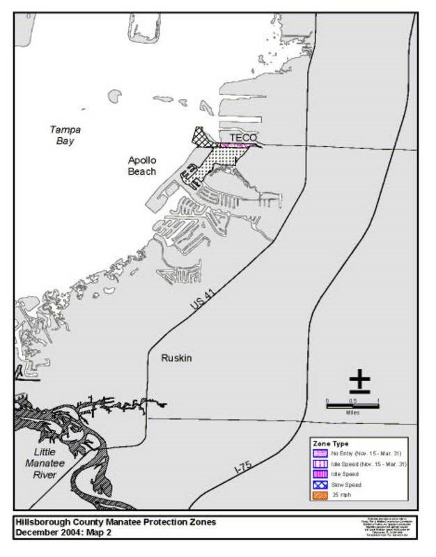
187(a) NO ENTRY (November 15 – March 31) Apollo Beach Area: All waters of the discharge canal of the Tampa Electric Company Big Bend Electric Generating Station east of a line bearing 193.6° from a point (approximate latitude 27°47226'22737.9" 228North, approximate longitude 82°24232'23342.7" 234West) on the northern shoreline of the discharge canal to a point (approximate latitude 27°47249'25033.8" 251North, approximate longitude 82°24255'25643.7" 257West) in the water along the existing fence line on the southern side of the discharge canal. The southern boundary is the southern shoreline of the discharge canal and a line bearing 271.6° for a distance of approximately 3039 feet from a point (approximate latitude 27°47303'30433.3" 305North, approximate longitude 82°24309'3109.9" 311West) on the southern shoreline to the aforementioned point on the existing fence line.
325(b) IDLE SPEED (November 15 – March 31) Apollo Beach Area: Those waters south of the Apollo Beach No Entry zone, generally east of the hammerhead portion of Apollo Beach, and north of Apollo Beach Boulevard, excluding the waters of Newman Branch and the canal system southeast of Dolphin Cove Drive. The northern boundary is the southern boundary of the No Entry zone described in paragraph (2)(a) and a line following the existing fence line beginning at a point (approximate latitude 27°47407'40833.8" 409North, approximate longitude 82°24413'41443.7" 415West) in the water on the fence line and bearing 301.7° to another point (approximate latitude 27°47432'43334.9" 434North, approximate longitude 82°24438'43945.8" 440West) on the fence line and then bearing 271.6° to the line452'453s terminus at a point (approximate latitude 27°47461'46235.1" 463North, approximate longitude 82°24467'46853.8" 469West) at the western end of the fence line. The western boundary is a line bearing 180° from the aforementioned point at the western end of the existing fence line to a point (approximate latitude 27°47505'50633.5" 507North, approximate longitude 82°24511'51253.8" 513West) on the northern shoreline of the hammerhead portion of Apollo Beach and then following the northern and eastern shorelines of the hammerhead portion of Apollo Beach to a point (approximate latitude 27°46546'54757.4" 548North, approximate longitude 82°25552'5534.2" 554West) on the shoreline of the peninsula that contains Dolphin Cove Drive. The eastern boundary is the general contour of the eastern shoreline of Tampa Bay south of the Apollo Beach No Entry zone to a point (approximate latitude 27°46594'59558.6" 596North, approximate longitude 82°25600'6012.5" 602West) on the southwestern shoreline of the mangrove peninsula west of Newman Branch and a line bearing 232.0° from said point on the mangrove peninsula to the aforementioned point on the shoreline of the peninsula that contains Dolphin Cove Drive.
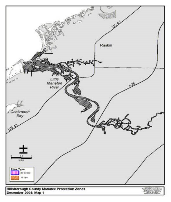
642(c) IDLE SPEED (All Year) – Little Manatee River/Bahia Beach: Those waters in the basin south and west of 661Bahia Beach Boulevard, 664including the seagrass area and entrance channel southwest of the basin. The southern and western boundary is a line bearing 323.6° for a distance of approximately 290 feet from a point (approximate latitude 27°43698'69919.1" 700North, approximate longitude 82°28704'70544.7" 706West) on the eastern shoreline of a canal on Shell Point to a point (approximate latitude 27°43723'72421.4" 725North, approximate longitude 82°28729'73046.7" 731West) in the water near the edge of the seagrass area, then bearing 338.1° for a distance of approximately 568 feet to a point (approximate latitude 27°43758'75926.5" 760North, approximate longitude 82°28764'76549.0" 766West) in the water, and then bearing 48.4° for a distance of approximately 864 feet to a point (approximate latitude 27°43787'78832.4" 789North, approximate longitude 82° 28794'79541.9" 796West) on the southwestern shoreline of Bahia Beach.
804(d) SLOW SPEED (All Year, except as otherwise designated).
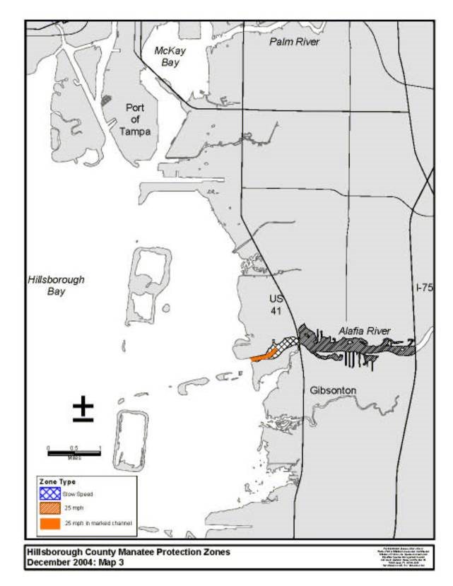
8131. Alafia River: All waters in the Alafia River outside of the main marked channel east of a line bearing 360° from a point (approximate latitude 27°51840'84110.0'' North, approximate longitude 82°23'54.2'' West) on the southern shoreline of the Alafia River at the river’s confluence with Hillsborough Bay, and west of the centerline of the U.S. Highway 41 Bridge.
8732. Apollo Beach Area: Those waters of Tampa Bay west of the Apollo Beach No Entry zone described in paragraph (2)(a) and bounded on the north and south by existing Hillsborough County zones and on the west by a line connecting the western boundaries of said Hillsborough County zones. The northern boundary is a line bearing 254.8° from a point (approximate latitude 27°47'37.9" 936North, approximate longitude 82°24940'94142.7" 942West) on the northern shoreline of the discharge canal of the Tampa Electric Company Big Bend Electric Generating Station to a point (approximate latitude 27°47967'96837.2" 969North, approximate longitude 82°24973'97444.9" 975West) on the southeastern shoreline of the unnamed island west of the generating station and then following the southern and western shorelines of said island to a point (approximate latitude 27°471006'100753.8" 1008North, approximate longitude 82°251012'10133.8" 1014West) on the northwestern shoreline of the island and then bearing 275.4° for a distance of approximately 598 feet to a point (approximate latitude 27°471039'104054.2" 1041North, approximate longitude 82°251045'104610.5" 1047West) in the water at the southwestern boundary of an existing Hillsborough County zone. The southern boundary is the northern boundary of the Idle Speed zone described in paragraph (2)(b) and a line beginning at a point (approximate latitude 27°471087'108833.5" 1089North, approximate longitude 82°241093'109453.8" 1095West) on the northern shoreline of the hammerhead portion of Apollo Beach and then following the northern and western shorelines of the hammerhead portion of Apollo Beach to a point (approximate latitude 27°471128'112935.1" 1130North, approximate longitude 82°251134'11358.0" 1136West) on the northwestern shoreline and then bearing 295.4° for a distance of approximately 739 feet to a point (approximate latitude 27°471158'115938.3" 1160North, approximate longitude 82°251164'116515.5" 1166West) in the water at the northwestern boundary of an existing Hillsborough County zone. The western boundary is a line bearing 196.2° from the aforementioned point in the water at the southwestern boundary of an existing 1202Hillsborough 1203County 1204zone to the aforementioned point in the water at the northwestern boundary of an existing 1219Hillsborough 1220County 1221zone.
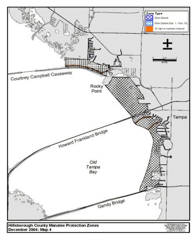
12223. 1223Old 1224Tampa 1225Bay 1226Area:
1227a. South of the Howard Frankland Bridge: All waters north of the Gandy Boulevard Bridge, south of the Howard Frankland Bridge, and east of a line beginning at a point (approximate latitude 27°531260'126124.0" 1262North, approximate longitude 82°321266'126743.4" 1268West) in the water under the westbound lane of Gandy Boulevard (approximately 1015 feet southwest of where Gandy Boulevard crosses the eastern shoreline of Old Tampa Bay) and then bearing 348.7° for a distance of approximately 475 feet to a point (approximate latitude 27°531312'131328.6" 1314North, approximate longitude 82°321318'131944.5" 1320West) in the water, then bearing 11.5° for a distance of approximately 700 feet to a point (approximate latitude 27°531340'134135.4" 1342North, approximate longitude 82°321346'134743.1" 1348West) in the water, then bearing 19.7° for a distance of approximately 4590 feet to a point (approximate latitude 27°541368'136918.3" 1370North, approximate longitude 82°321374'137526.4" 1376West) in the water, then bearing 15.2° for a distance of approximately 3155 feet to a point (approximate latitude 27°541396'139748.6" 1398North, approximate longitude 82°321402'140317.6" 1404West) in the water, then bearing 8.2° for a distance of approximately 1855 feet to a point (approximate latitude 27°551424'14256.8" 1426North, approximate longitude 82°321430'143114.9" 1432West) in the water, then bearing 11.7° for a distance of approximately 1660 feet to a point (approximate latitude 27°551452'145322.9" 1454North, approximate longitude 82°321458'145911.4" 1460West) in the water, then bearing 3.1° for a distance of approximately 617 feet to a point (approximate latitude 27°551480'148129.2" 1482North, approximate longitude 82°321486'148711.1" 1488West) in the water, then bearing 347.3° for a distance of approximately 919 feet to a point (approximate latitude 27°551508'150937.9" 1510North, approximate longitude 82°321514'151513.5" 1516West) in the water, then bearing 334.8° for a distance of approximately 1735 feet to a point (approximate latitude 27°551536'153753.4" 1538North, approximate longitude 82°321542'154322.0" 1544West) in the water, then bearing 298.0° for a distance of approximately 2315 feet to a point (approximate latitude 27°561564'15653.9" 1566North, approximate longitude 82°321570'157144.9" 1572West) in the water, then bearing 290.2° for a distance of approximately 998 feet to a point (approximate latitude 27°561592' 15937.2" 1594North, approximate longitude 82°321598'159955.4" 1600West) in the water, then bearing 313.6° for a distance of approximately 526 feet to a point (approximate latitude 27°561620'162110.7" 1622North, approximate longitude 82°321626'162759.7" 1628West) in the water, then bearing 333.6° for a distance of approximately 884 feet to a point (approximate latitude 27°561648'164918.4" 1650North, approximate longitude 82°331654'16554.2" 1656West) in the water, and then bearing 349.0° for a distance of approximately 645 feet to the line1674'1675s terminus at a point (approximate latitude 27°56'24.7" 1683North, approximate longitude 82°331687'16885.7" 1689West) on the southern shoreline of the causeway for the Howard Frankland Bridge (approximately 1289 feet southwest of where Interstate 275 crosses the eastern shoreline of Old Tampa Bay), except as otherwise designated under sub-subparagraph (2)(e)4.a.
1725b. Rocky Point Area: All waters north of the Howard Frankland Bridge and northeast of a line bearing 321.6° from a point (approximate latitude 27°561750'175126.6" 1752North, approximate longitude 82°331756'17576.2" 1758West) on the northern shoreline of the causeway for the Howard Frankland Bridge to a point (approximate latitude 27°571777'177842.8" 1779North, approximate longitude 82°341783'178416.0" 1785West) on the southwestern shoreline of Rocky Point.
1793c. North of Courtney Campbell Causeway (April 1 – November 15): All waters north of the Courtney Campbell Causeway and east of a line bearing 360° from a point (approximate latitude 27°581825'182624.5" 1827North, approximate longitude 82°351831'183257.2" 1833West) on the northern shoreline of the Courtney Campbell Causeway to a point on the northeastern shoreline of Old Tampa Bay east of the mouth of Rocky Creek, except as otherwise designated under sub-subparagraph (2)(e)4.b. and excluding those waters of the canal system and basin of the Dana Shores area east of a line bearing 346.7° from a point (approximate latitude 27°581895'189621.5" 1897North, approximate longitude 82°331901'190256.0" 1903West) on the southern shoreline of the entrance canal to a point (approximate latitude 27°581918'191923.7" 1920North, approximate longitude 82°331924'192556.6" 1926West) on the northern shoreline of the entrance canal.
1935(e) 25 MPH (All Year, except as otherwise designated).
19441. Alafia River, West of U.S. Highway 41: All waters in the main marked channel of the Alafia River east of a line bearing 360° from a point (approximate latitude 27°511975'197610.0'' North, approximate longitude 82°23'54.2'' West) on the southern shoreline of the Alafia River at the river’s confluence with Hillsborough Bay, and west of the centerline of the U.S. Highway 41 Bridge.
20082. 2009Alafia River, 2011U.S. 2012Highway 41 to Interstate 75: All waters of the 2021Alafia 2022River 2023east of the centerline of the U.S. Highway 41 Bridge and west of the centerline of the Interstate 75 Bridge.
20433. Little Manatee River: All waters of the Manatee River and the portion of Tampa Bay south and east of a line beginning at a point (approximate latitude 27°43'32.4" 2072North, approximate longitude 82°282076'207741.9" 2078West) on the southwestern shoreline of Bahia Beach and then bearing 288.8° for a distance of approximately 576 feet to a point (approximate latitude 27°432103'210434.1" 2105North, approximate longitude 82°282109'211048.0" 2111West) in the water, then bearing 220.7° for a distance of approximately 1503 feet to a point (approximate latitude 27°432131'213222.7" 2133North, approximate longitude 82°282137'213858.8" 2139West) in the water, then bearing 207.3° for a distance of approximately 661 feet to a point (approximate latitude 27°43'16.9" 2159North, approximate longitude 82°292163'21642.1" 2165West) in the water, then bearing 226.5° for a distance of approximately 483 feet to a point (approximate latitude 27°432185'218613.5" 2187North, approximate longitude 82°292191'21925.9" 2193West) in the water, then bearing 199.8° to a point (approximate latitude 27°432206'22079.9" 2208North, approximate longitude 82°29'7.3" 2212West) on the northeastern shoreline of Tropical Island, then following the northeastern shoreline to a point (approximate latitude 27°422231'223259.0" 2233North, approximate longitude 82°282237'223853.0" 2239West) on the eastern shoreline of said island, then following the southern shoreline to a point (approximate latitude 27°432258'22594.0" 2260North, approximate longitude 82°292264'226515.1" 2266West) near the western end of said island, then bearing 264.0° to a point (approximate latitude 27°432283'22842.6" 2285North, approximate longitude 82°292289'229027.7" 2291West) on the eastern shoreline of Sand Key (the large unnamed mangrove island to the west of Tropical Island), then following the eastern shoreline of Sand Key to a point (approximate latitude 27°422324'232543.1" 2326North, approximate longitude 82°292330'233130.3" 2332West) on the southern shoreline, then bearing 145.3° to the line2343'2344s terminus at a point (approximate latitude 27°42'41.6" 2352North, approximate longitude 82°292356'235729.1" 2358West) on the shoreline of the mangrove peninsula west of Seabreeze Drive.
23704. Old Tampa Bay Area: Those waters in the portions of the following marked channels east of the western boundary of the Slow Speed zones designated in subparagraph (2)(d)3.:
2399a. South of the Howard Frankland Bridge: Those waters in the marked channel leading to Culbreath Bayou west of channel marker “9” (approximate latitude 27°562424'242513.1" 2426North, approximate longitude 82°312430'243156.4" 2432West); and those waters in the portion of the marked channel south of the Howard Frankland Bridge (south of Mariner Drive) west of channel marker “12” (approximate latitude 27°562461'246225.4" 2463North, approximate longitude 82°322467'246817.9" 2469West), but excluding the north-south portion of the channel between channel marker “12” and channel marker “16.”
2486b. North of Courtney Campbell Causeway (April 1 – November 15): Those waters in the marked east-west channel leading to Dana Shores (generally east of channel marker “5”) west of channel marker “23” (approximate latitude 27°582522'252318.8" 2524North, approximate longitude 82°342528'252910.0" 2530West).
2531(3) 2532The zones described in subsection 253768C-22.013(2), 2538F.A.C., are depicted on the following maps, labeled “Hillsborough County Manatee Protection Zones.” The maps are intended to depict the above-described zones. In the event of conflict between the maps and descriptions, the descriptions shall prevail.
2574(4) The amendments to Rule 257968C-22.013, 2580F.A.C., as approved by the Commission on September 22, 2004, shall take effect as soon as the regulatory markers are posted.


2601Specific Authority 370.12(2)(g), (n), (o) FS. Law Implemented 370.12(2)(d), (g), (k), (n) FS. History–New 3-19-79, Formerly 16N-22.13, 16N-22.013, 62N-22.013, Amended 12-12-02, 1-5-05.


