 |
Florida Administrative Code (Last Updated: November 11, 2024) |
 |
68. Fish and Wildlife Conservation Commission |
|
68C. Manatees |
|
68C-22. The Florida Manatee Sanctuary Act |
1(1) 2The Commission hereby designates the waters within 9Sarasota 10County 11(and a small portion of 16Charlotte 17County18), as described below, as areas where manatee sightings are frequent and where the best available information supports the conclusion that manatees inhabit these areas on a regular or periodic basis. 49The 50primary 51purpose of this rule is to protect manatees 59from harmful collisions with motorboats and from harassment by establishing safe havens and regulating the speed and operation of motorboats within these designated areas. A secondary purpose is to protect manatee habitat91.
92(a) 93In consideration of balancing the rights of fishers, boaters, and water skiers to use the waters of the state for recreational and commercial purposes (as applicable under Section 121379.2431(2)(k), F.S.123), with the need to provide manatee protection, the Commission has examined the need for limited lanes, corridors, or unregulated areas that allow higher speeds through or within regulated areas. Such lanes, corridors, or areas are provided in those locations where the Commission determined they are consistent with manatee protection needs. Access to the NO ENTRY zones designated hereunder will be provided in accordance with the procedures set forth in 193Rule 19468C-22.003, 195F.A.C.
196(b) All zones include all associated and navigable tributaries, lakes, creeks, coves, bends, backwaters, canals, channels and boat basins, and other waterways unless otherwise designated or excluded. Coordinates used in the descriptions of zone boundaries are referenced to the North American Datum of 1983 (NAD83).
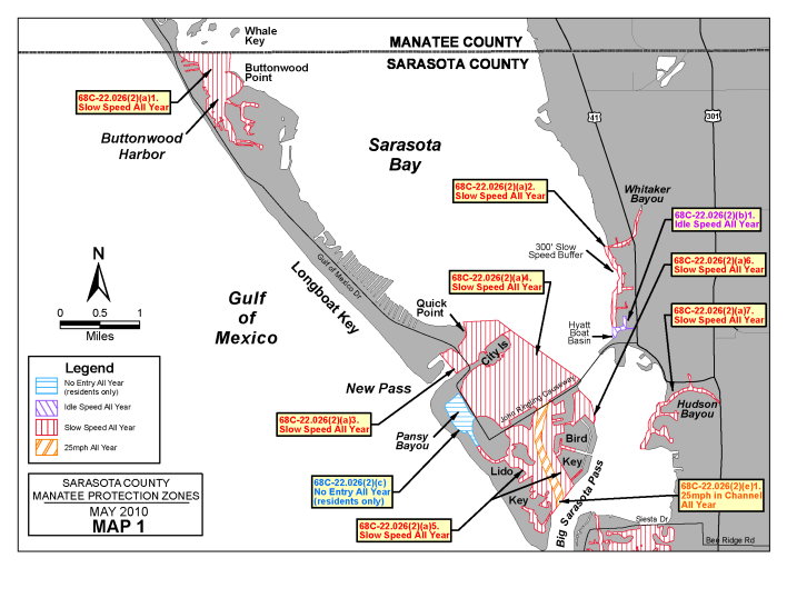
241(2) 242The 243following year-round zones are established 248within the coastal waters of 253Sarasota 254County255:
256(a) SLOW SPEED.
2591. Buttonwood Harbor, Cranes Bayou Area: All 266waters of 268Buttonwood Harbor and Cranes Bayou; 273and, all waters of Sarasota Bay, north of Buttonwood Harbor, e284ast 285of 286Longboat Key, 288south of the Manatee County line, and west of a line that bears 6° from 303the westernmost 305point of Buttonwood Point (approximate latitude 27° 23' 10" North, approximate longitude 82° 37' 47" West);
3212. 322Whitaker Bayou Area: All waters of Whitaker Bayou south of the centerline of the 27th Street Bridge; 339and, those waters 342of Sarasota Bay within 300 feet of the 350eastern 351shoreline of Sarasota Bay, south of a line 359that 360bears 361270° 362from a point at the intersection of the northern shoreline of Whitaker Bayou with the 377eastern 378shoreline of Sarasota Bay (approximate latitude 27° 21' 38612" 387North, approximate longitude 82° 33' 39208" 393West), and north of the westerly extension of the seawall forming the northern shore of the entrance to the Hyatt Boat Basin;
4153. 416New Pass: All waters of New Pass 423and Sarasota Bay, south and west 429of a line 432that begins at 435the 436northeasternmost 437tip of Quick Point on Longboat Key (approximate latitude 27° 20' 44820" 449North, approximate longitude 82° 34' 45455" 455West) 456and bears 345° for a distance of approximately 400 feet to Point No. 1 in Sarasota Bay (latitude 27° 20' 24" North, longitude 82° 34' 56" West) then bears 87° for a distance of approximately 2285 feet to Point No. 2 in Sarasota Bay (latitude 27° 20' 25" North, longitude 82° 34' 31" West) then bears 128° for a distance of approximately 1130 feet to Point No. 3 in Sarasota Bay (latitude 27° 20' 18" North, longitude 82° 34' 21" West) roughly 600 feet east of Lighted Green Channel Marker “13” (latitude 27° 20' 18" North, longitude 82° 34' 28" West), north of Lido Key, City Island, and a line running from the northernmost point of City Island to the aforementioned Point No. 3, 580and northeast of a line 585that 586bears 587320° 588through Green Day Marker “9” (approximate latitude 27° 19' 53" North, approximate longitude 82° 35' 04" West);
6054. 606City Island Lagoon Area: All waters of Sarasota Bay, including the City Island Lagoon area, 621southwest of a line that bears 125° from a point in Sarasota Bay (latitude 27° 20' 18" North, longitude 82° 34' 21" West) to the northernmost point of Bird Key (approximate latitude 27° 19' 45" North, approximate longitude 82° 33' 31" West), 663northwest of 665Bird Key and 668Coon Key and the centerline of the John Ringling Boulevard Bridges (connecting Bird Key to Coon Key and Coon Key to St. Armands Key), northeast 693of S695t. Armands Key and the shoreline of City Island adjacent to John Ringling Parkway running northwest from St. Armands Key and the centerline of the John Ringling 722Parkway Bridge connecting St. Armands Key to City Island, and southeast of Lido Key, City Island, and a line running from the northernmost point of City Island to the aforementioned point in Sarasota Bay;
7565. Lido Key Area: All waters of Sarasota Bay south of Coon Key and St. Armands Key and the centerline of the John Ringling Boulevard Bridges (connecting Bird Key to Coon Key, Coon Key to St. Armands Key, and St. Armands Key to Lido Key), east of Lido Key, west of Bird Key and the centerlines of the Bird Key Drive Bridges and the Wild Turkey Lane Bridge, and northwest of a line that bears 218° from the southernmost point of Bird Key (approximate latitude 27° 18' 36" North, approximate longitude 82° 33' 36" West) to a point on the eastern shoreline of Lido Key (approximate latitude 27° 18' 17" North, approximate longitude 82° 33' 53" West), except as otherwise designated under paragraph (2)(e);
8806. Bird Key Area: All waters of the basin on the northeast side of Bird Key east of the centerline of the northern Bird Key Drive Bridge; and, those waters of Sarasota Bay west of a line that begins at a point on the eastern shoreline of Bird Key (approximate latitude 27° 19' 16" North, approximate longitude 82° 33' 21" West) roughly 850 feet southeast of the northernmost point of land containing Meadow Lark Drive, then bears 19° for a distance of approximately 350 feet to Point No. 1 in Sarasota Bay (latitude 27° 19' 19" North, longitude 82° 33' 19" West) then bears 344° for a distance of approximately 1150 feet to Point No. 2 in Sarasota Bay (latitude 27° 19' 30" North, longitude 82° 33' 23" West) then bears 315° for a distance of approximately 1080 feet to the line’s terminus at a point on the northeast shoreline of Bird Key (approximate latitude 27° 19' 38" North, approximate longitude 82° 33' 31" West);
10457. 1046Hudson Bayou Area: All waters of Hudson Bayou to its headwaters and that part of Sarasota Bay within 300 feet of the general contour of the 1072eastern 1073shoreline of Sarasota Bay, south of a line 1081that 1082bears 1083270° 1084from a point at the intersection of the 1092northern 1093shoreline of Hudson Bayou with the 1099eastern 1100shoreline of Sarasota Bay (approximate latitude 27° 19' 110829" 1109North, approximate longitude 82° 32' 111428" 1115West), and north of a line 1121that 1122bears 1123270° f1125rom a point 1128on the southwestern shoreline of the peninsula that contains Vista Drive 1139(approximate latitude 27° 18' 114359" 1144North, approximate longitude 82° 32' 43" West);
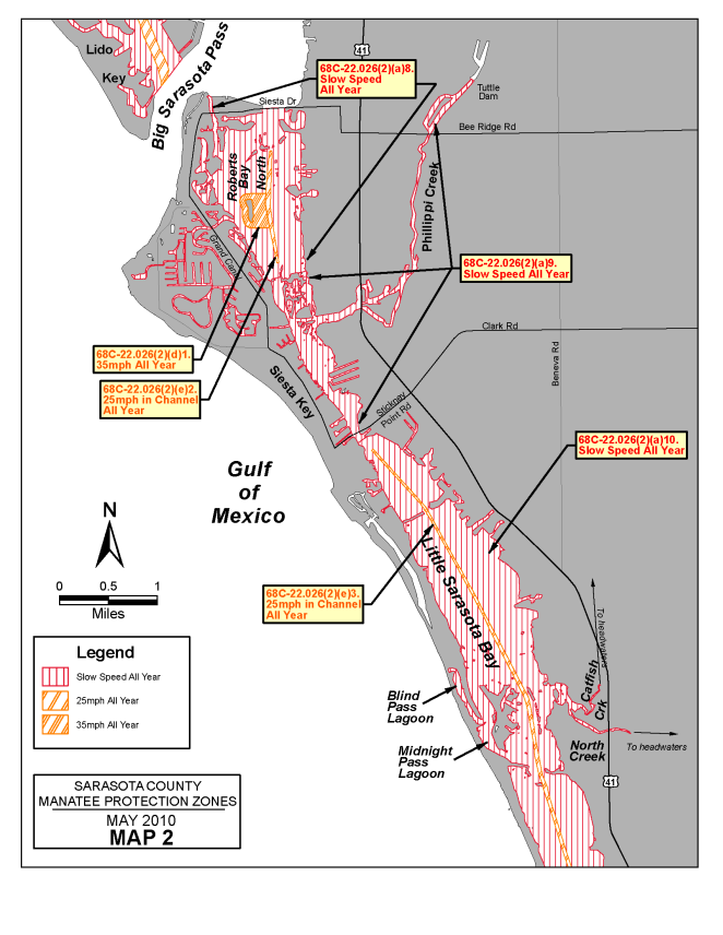
11518. 1152Roberts Bay Area (north): All waters of Roberts Bay south of the centerline of the Siesta Drive Bridge (State Road 789) (connecting Bay Island with the mainland) and north of a line located 775 feet south of and parallel with a line that bears 78° running through Green Intracoastal Waterway Channel Marker “75” (approximate latitude 27° 16' 46" North, approximate longitude 82° 32' 41" West), including all waters of Hansen Bayou south of the general contour of the northern shoreline of Siesta Key, South Coconut Bayou, Coconut Bayou, and all waters associated with the Grand Canal waterway system throughout Siesta Key, except as otherwise designated under paragraphs (2)(d) and (2)(e);
12629. 1263Little Sarasota Bay, Phillippi Creek Area: All waters of Little Sarasota Bay south of a line located 775 feet south of and parallel with a line that bears 78° running through Flashing Green Intracoastal Waterway Channel Marker “75” (approximate latitude 27° 16' 46" North, approximate longitude 82° 32' 41" West), and north of a line located 250 feet south of and parallel with a line that bears 50° running through Green Intracoastal Waterway Channel Marker “61” (approximate latitude 27° 15' 07" North, approximate longitude 82° 31' 48" West); and, all waters of Phillippi Creek southwest of the dam located northeast of the Tuttle Avenue Bridge;
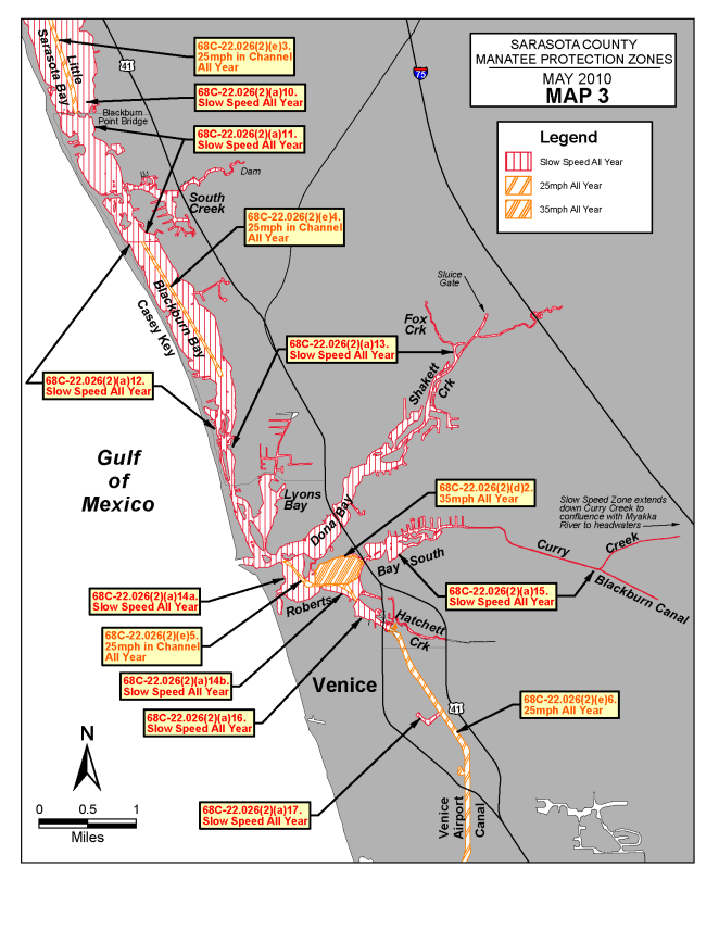
136810. 1369Little Sarasota Bay Area: All waters of Little Sarasota Bay, including all waters of Blind Pass Lagoon, Midnight Pass Lagoon, North Creek and Catfish Creek to the headwaters of said creeks, south of a line located 250 feet south of and parallel with a line that bears 50° running through Green Intracoastal Waterway Channel Marker “61” (approximate latitude 27° 15' 07" North, approximate longitude 82° 31' 48" West), and north of the centerline of the Blackburn Point Bridge (County Road 789), except as otherwise designated under paragraph (2)(e);
145711. Little Sarasota Bay, Dryman Bay and South Creek Area: All waters of Little Sarasota Bay, Dryman Bay, and Blackburn Bay south of the centerline of the Blackburn Point Bridge and north of a line that bears 90° running through Green Intracoastal Waterway Channel Marker “23” (approximate latitude 27° 09' 38" North, approximate longitude 82° 29' 03" West); and, all waters of South Creek to the dam in Oscar Scherer State Park;
152912. Blackburn Bay Area: All waters of Blackburn Bay south of a line that bears 90° running through Green Intracoastal Waterway Channel Marker “23” (approximate latitude 27° 09' 38" North, approximate longitude 82° 29' 03" West), and north of a line that bears 90° running through Green Intracoastal Waterway Channel Marker “13” (approximate latitude 27° 07' 53" North, approximate longitude 82° 28' 13" West), except as otherwise designated under paragraph (2)(e);
160013. Blackburn Bay, Lyons Bay, Dona Bay, Shakett Creek and Venice Inlet Area: All waters of Blackburn Bay, Lyons Bay, Dona Bay, and Venice Inlet, south of a line that bears 90° running through Green Intracoastal Waterway Channel Marker “13” (approximate latitude 27° 07' 53" North, approximate longitude 82° 28' 13" West), north of a line that bears approximately 68° running through Red Intracoastal Waterway Channel Marker “16” (approximate latitude 27° 06' 47" North, approximate longitude 82° 27' 37" West) to the northernmost tip of land of the Enchanted Island Subdivision containing Anchorage Drive (approximate latitude 27° 06' 51" North, approximate longitude 82° 27' 26" West), and, east of a line that bears 170° running through Green Venice Inlet Day Beacon “3” (approximate latitude 27° 06' 48" North, approximate longitude 82° 28' 02" West); and all waters of Shakett Creek south of the control structure southwest of Interstate Highway 75, including all waters of Fox Creek and Salt Creek to the headwaters of said creeks;
176514. 1766Roberts 1767Bay 1768(south) Area: Those waters of 1773Roberts 1774Bay, 1775as follows, except as otherwise designated under paragraph (2)(e):
1784a. Those waters of Roberts Bay south of a line that bears approximately 68° running through Red Intracoastal Waterway Channel Marker “16” (approximate latitude 27° 06' 47" North, approximate longitude 82° 27' 37" West) to the northernmost tip of land of the Enchanted Island Subdivision containing Anchorage Drive (approximate latitude 27° 06' 51" North, approximate longitude 82° 27' 26" West), and, and west of a line that bears 360° running through Red Intracoastal Waterway Channel Marker “12” (approximate latitude 27° 06' 34" North, approximate longitude 82° 27' 19" West); and
1874b. Those waters of Roberts Bay east of a line that bears 360° running through Red Intracoastal Waterway Channel Marker “12” (approximate latitude 27° 06' 34" North, approximate longitude 82° 27' 19" West), northwest of a line that bears 60° running through Red Intracoastal Waterway Channel Marker “8” (approximate latitude 27° 06' 26" North, approximate longitude 82° 26' 54" West), south of the northern boundary of the main marked channel of the Intracoastal Waterway between Red Intracoastal Waterway Channel Marker “12” and Red Intracoastal Waterway Channel Marker “10” (approximate latitude 27° 06' 34" North, approximate longitude 82° 27' 00" West), and south of a line that bears 60° from Red Intracoastal Waterway Channel Marker “10” to the eastern shoreline of Roberts Bay;
199615. Roberts Bay (South), Curry Creek and Blackburn Canal Area: Those waters of Roberts Bay within 100 feet of the general contour of the eastern shoreline of Roberts Bay west of U.S. Highway 41, north of a line that bears 60° from Red Intracoastal Waterway Channel Marker “10” (approximate latitude 27° 06' 34" North, approximate longitude 82° 27' 00" West) to the eastern shoreline of Roberts Bay, and east of a line that bears 180° from a point on the northern shoreline of Roberts Bay (approximate latitude 27° 06' 49" North, approximate longitude 82° 27' 01" West); and, all waters of Curry Creek from Roberts Bay to the Myakka River, and all waters of Blackburn Canal to its headwaters;
211516. Hatchett Creek: All waters of Hatchett Creek west of the centerline of U.S. Highway 41 (Venice By-Pass), south of a line that bears 60° running through Red Intracoastal Waterway Channel Marker “8” (approximate latitude 27° 06' 26" North, approximate longitude 82° 26' 54" West), and north of a line that bears 25° located 400 feet southeast of the centerline of the U.S. 41 (Business) Bridge, as measured along the centerline of the Intracoastal Waterway;
219017. Country Club Estates Area: All waters of the boat basin serving the Country Club Estates mobile home park, southwest of the general contour of the southwestern shoreline of the Venice Airport Canal; and
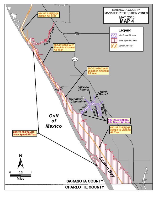
222418. Alligator Creek, Lemon Bay Area: All waters of Alligator Creek southwest of the centerline of the U.S. Highway 41 Bridge; and, all waters of Lemon Bay southeast of a line that bears 50° running through Red Intracoastal Waterway Channel Marker “52” (approximate latitude 27° 02' 46" North, approximate longitude 82° 25' 59" West), and north of the Sarasota/Charlotte County line, except as otherwise designated under paragraphs (2)(b) and (2)(e).
2294(b) IDLE SPEED.
22971. Hyatt Boat Basin: All waters of the Hyatt Boat Basin and that portion of Sarasota Bay east of a line that bears 180° from a point in Sarasota Bay (approximate latitude 27° 20' 19" North, approximate longitude 82° 33' 07" West) 300 feet west of the corner of the seawall at the southwest corner of the Hyatt site (approximate latitude 27° 20' 19" North, approximate longitude 82° 33' 03" West), and south of a line that bears 90° from the aforementioned point in Sarasota Bay to the corner of the seawall at the southwest corner of the Hyatt site; and
23982. Forked Creek Area: All waters of Forked Creek east of its confluence with 2412Lemon 2413Bay; 2414and, all waters of 2418Waterford 2419Canal, 2420Windsor 2421Canal, 2422Greenlawn Channel, Fairview Channel, and North Branch.
2429(c) NO ENTRY – Pansy Bayou: All waters of that body of water commonly known as Pansy Bayou (being that body of water north and west of St. Armands Key), west of the centerline of the northbound lane of 2468John Ringling Parkway, 2471and north of the centerline of the westbound lane of 2481John Ringling Boulevard2484.
2485(d) MAXIMUM 35 MPH.
24891. Roberts Bay (north) Area: Those waters of Roberts Bay surrounding the spoil island commonly referred to as “Skiers Island” located approximately 700 feet west of the Intracoastal Waterway near Green Intracoastal Waterway Channel Marker “79” (approximate latitude 27° 17' 18" North, approximate longitude 82° 32' 47" West), bounded on the north by a line that bears 90° located 300 feet north of the northernmost tip of the shoreline of the spoil island, bounded on the south by a line that bears 90° located 300 feet south of the southernmost tip of the shoreline of the spoil island, bounded on the west by a line 300 feet west of and parallel with the general contour of the western shoreline of the spoil island, and bounded on the east by the western boundary of the main marked channel of the Intracoastal Waterway; and
26312. Roberts Bay (south) Area: Those waters of Roberts Bay, east of a line that bears 360° running through Red Intracoastal Waterway Channel Marker “12” (approximate latitude 27° 06' 34" North, approximate longitude 82° 27' 19" West), north of the northern boundary of the main marked channel of the Intracoastal Waterway between Red Intracoastal Waterway Channel Marker “12” and Red Intracoastal Waterway Channel Marker “10” (approximate latitude 27° 06' 34" North, approximate longitude 82° 27' 00" West) and a line that bears 60° from Red Intracoastal Waterway Channel Marker “10” to the eastern shoreline of Roberts Bay, and west of U.S. Highway 41, excluding those waters within 100 feet of the shoreline as designated under subparagraph (2)(a)15.
2748(e) MAXIMUM 25 MPH.
27521. Lido Key Area: All waters of the unnamed main marked channel south of the centerline of the John Ringling Boulevard Bridge connecting Bird Key to Coon Key, and north of a line that bears 218° from the southernmost point of Bird Key (approximate latitude 27° 18' 36" North, approximate longitude 82° 33' 36" West) to a point on the eastern shoreline of Lido Key (approximate latitude 27° 18' 17" North, approximate longitude 82° 33' 53" West);
28292. Roberts Bay (north): All waters of the main marked channel of the Intracoastal Waterway south of a line that bears 90° from the southernmost point of Big Edward’s Island (approximate latitude 27° 17'436" North, approximate longitude 82° 32' 48" West), and north of a line that bears 78° running through Green Intracoastal Waterway Channel Marker “75” (approximate latitude 27° 16' 46" North, approximate longitude 82° 32' 41" West);
28983. Little Sarasota Bay Area: All waters of the main marked channel of the Intracoastal Waterway south of a line located 250 feet south of and parallel with a line that bears 50° running through Green Intracoastal Waterway Channel Marker “61” (approximate latitude 27° 15' 07" North, approximate longitude 82° 31' 48" West), and north of the centerline of the Blackburn Point Bridge (County Road 789);
29644. Blackburn Bay Area: All waters of the main marked channel of the Intracoastal Waterway south of a line that bears 90° running through Green Intracoastal Waterway Channel Marker “23” (approximate latitude 27° 09' 38" North, approximate longitude 82° 29' 03” West), and north of a line that bears 78° running through Green Intracoastal Waterway Channel Marker “15” (approximate latitude 27° 08' 25" North, approximate longitude 82° 28' 16" West);
30345. Roberts Bay (south) Area: All waters of the main marked channel of the Intracoastal Waterway south of a line that bears approximately 68° running through Red Intracoastal Waterway Channel Marker “16” (approximate latitude 27° 06' 47" North, approximate longitude 82° 27' 37" West) and northwest of a line that bears 60° running through Red Intracoastal Waterway Channel Marker “8” (approximate latitude 27° 06' 26" North, approximate longitude 82° 26' 54" West);
31066. Venice Airport Canal: All waters of the Venice Airport Canal, south of a line that bears 25° located 400 feet southeast of the centerline of the U.S. 41 (Business) Bridge, as measured along the centerline of the Intracoastal Waterway, and northwest of a line that bears 50° running through Red Intracoastal Waterway Channel Marker “52” (approximate latitude 27° 02' 46" North, approximate longitude 82° 25' 59" West), except those waters northwest of the canal associated with Red Lake;
31857. North Lemon Bay Area: All waters of the main marked channel of the Intracoastal Waterway southeast of a line that bears 50° running through Red Intracoastal Waterway Channel Marker “52” (approximate latitude 27° 02' 46" North, approximate longitude 82° 25' 59" West), and north of the centerline of the Manasota Beach Bridge (County Road 774);
32418. Central Lemon Bay Area: All waters of the main marked channel of the Intracoastal Waterway south of a line 1000 feet south of and parallel with the centerline of the Manasota Beach Bridge (County Road 774) and north of a line 1400 feet south of and parallel with a line that bears 57° running through Green Intracoastal Waterway Channel Marker “39” (approximate latitude 26° 59' 52" North, approximate longitude 82° 24' 07" West); and,
33169. South Lemon Bay Area: All waters of the main marked channel of the Intracoastal Waterway south of a line 1100 feet north of and parallel with a line that bears 53° running through Green Intracoastal Waterway Channel Marker “37” (approximate latitude 26° 59' 10" North, approximate longitude 82° 23' 36" West, and north of the Sarasota County/Charlotte County line.
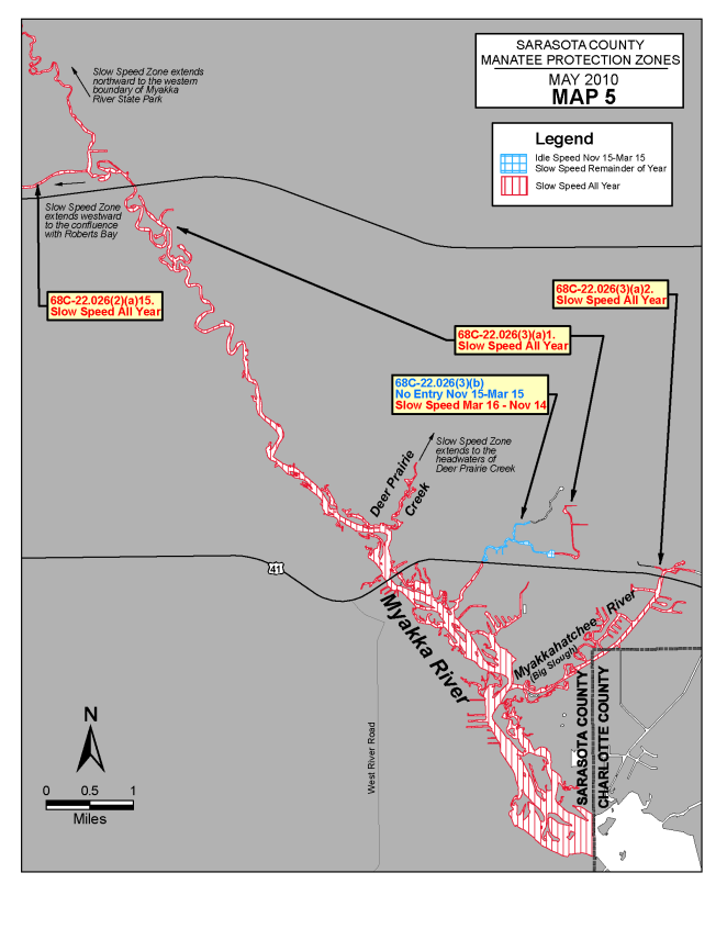
3376(3) The following year-round and seasonal zones are established within the Myakka River-Big Slough area of 3392Sarasota 3393County 3394and associated waters of 3398Charlotte 3399County3400:
3401(a) SLOW SPEED.
34041. Myakka River Area: All waters of the Myakka River northwest of the Sarasota County/Charlotte County line and southwest of the western line of Myakka River State Park (said line being the westerly line of Section 7, Township 38 South, Range 20 East), including all associated waters in and around the Warm Mineral Springs development, and Deer Prairie Creek to its headwaters, excluding the section of Salt Creek and Warm Mineral Springs upstream (northeast) of the weir (approximate latitude 27° 03' 17" North, approximate longitude 82° 15' 52" West) located approximately 2300 feet downstream (southwest) of the headwaters of Warm Mineral Springs and also excluding the area otherwise designated for seasonal regulation under paragraph (3)(b) when said seasonal zone is in effect; and
35272. Big Slough Area: Those waters of Big Slough and associated waterways northeast of the Myakka River and southwest of the dam north of U.S. Highway 41.
3554(b) NO ENTRY (November 15 – March 15) – Warm Mineral Springs/Salt Creek Area: Those waters of Salt Creek and Warm Mineral Springs north of the centerline of U.S. Highway 41, south of the weir (approximate latitude 27° 03’ 17" North, approximate longitude 82° 15' 52" West) located approximately 2300 feet downstream (southwest) of the headwaters of Warm Mineral Springs, and west of a line bearing 6° from a point (approximate latitude 27° 02' 56" North, approximate longitude 82° 15' 43" West) on the southern shoreline of Salt Creek approximately 2600 feet east of the confluence with the Warm Mineral Springs run.
3656(4) 3657Commercial Fishing Permits: The following provisions pertain to the issuance of permits to allow individuals engaged in commercial fishing activities to operate their vessels in specified areas at speeds greater than the speed limits established under subsection (2) above. Procedures related to the application for and the review and issuance of these permits are as set forth in Rule 371668C-22.003, 3717F.A.C.
3718(a) 3719Permits shall be limited as follows:
37251. 3726Permits shall only be available for the zones or portions of zones described under subparagraphs (2)(a)1., 2., 9. through 17, and 19., above;
37492. Permits shall not apply on weekends or on the holidays identified in Section 3763110.117, F.S.; 3765and
37663. Permits shall only apply to commercial fishing activities for the setting of nets to encircle fish, and shall only allow speeds up to 20 mph.
3792(b) Permit applications may be obtained from the Commission’s Law Enforcement office at 38055110 Gandy Boulevard, 3808Tampa, 3809Florida, 3810or by contacting the Commission’s Division of Law Enforcement (Boating and Waterways Section) at 3824620 South Meridian Street, 3828Tallahassee, 3829Florida 383032399-1600, 3831(850) 488-5600).
3833(5) The zones described in subsections 383968C-22.026(2) 3840and (3), F.A.C., are depicted on the following maps labeled “Sarasota County Manatee Protection Zones.” The maps are intended as depictions of the above-described zones. In the event of conflict between the maps and descriptions, the descriptions shall prevail.
3879(6) 3880The amendments to Rule 388468C-22.026, 3885F.A.C., as approved by the Commission on 3892April 28, 2010, 3895shall take effect as soon as the regulatory markers are posted.
3906Rulemaking Authority 3908379.2431(2)(g), 3909(n), (o) FS. Law Implemented 3914379.2431(2)(d), 3915(k), (n), (o) FS. History–New 1-27-92, Formerly 16N-22.026, 62N-22.026, Amended 12-12-02, 6-24-10.


