 |
Florida Administrative Code (Last Updated: November 11, 2024) |
 |
68. Fish and Wildlife Conservation Commission |
|
68D. Vessel Registration and Boating Safety |
|
68D-24. Boating Restricted Areas |
1(1) For the purpose of regulating speed and operation of vessel traffic on the Intracoastal Waterway within Palm Beach County, Florida, the following boating restricted areas are established:
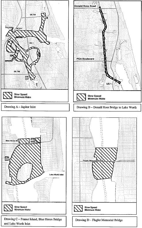
29(a) Jupiter Inlet – A Slow Speed Minimum Wake zone from shoreline to shoreline, in and adjacent to the Florida Intracoastal Waterway, bounded on the north by a line drawn perpendicular to the centerline of the Florida Intracoastal Waterway 300 feet north of the north end of the fender of the SR 707 (Gomez Rd.) Bridge; bounded on the northwest by a line drawn perpendicular to the centerline of the Loxahatchee River 300 feet northwest of the northwest end of the fender of the Florida East Coast Railroad bridge located adjacent to the SR 811 (Alternate A-1-A) Bridge; bounded on the south by a line drawn perpendicular to the centerline of the Florida Intracoastal Waterway 500 feet south of the south end of the fender of the SR 706 (Indiantown Rd.) Bridge; and bounded on the east by a line drawn due north across the Jupiter Inlet from the western tip of the jetty at DuBois Park to the southwest corner of Jupiter Island, and including all waters of and tributaries to Sawfish Bay and the Jupiter River, as depicted in drawing A.
212(b) Donald Ross Bridge – A Slow Speed Minimum Wake zone from shoreline to shoreline, in and adjacent to the Florida Intracoastal Waterway, bounded on the north by a line drawn perpendicular to the centerline of the Florida Intracoastal Waterway 300 feet north of the north end of the fender of the Donald Ross Bridge, and bounded on the south by a line drawn from headland to headland across the mouth of Lake Worth Creek at its southern terminus at Lake Worth, as depicted in drawing B.
299(c) Peanut Island, Blue Heron Bridge and Lake Worth Inlet – A Slow Speed Minimum Wake zone from shoreline to shoreline, in and adjacent to the Florida Intracoastal Waterway including all waters of Lake Worth, bounded on the north by a line drawn perpendicular to the centerline of the Florida Intracoastal Waterway at the north shoreline of Phil Foster Island, from the mainland at Riviera Beach to Singer Island; bounded on the southeast by a line drawn from the southwest corner of Singer Island to the nearest channel marker marking the northern edge of the Lake Worth Inlet Channel (flashing marker “8”) and running along the line of channel markers marking the northern edge of the Lake Worth Inlet Channel and the Port of Palm Beach Turning Basin to the westernmost channel marker marking the northern edge of the Port of Palm Beach Turning Basin (flashing marker “12”); and bounded on the south by a line drawn perpendicular to the centerline of the Florida Intracoastal Waterway, from the westernmost channel marker marking the northern edge of the Port of Palm Beach Turning Basin to the mainland at the southeast corner of the Port of Palm Beach Slip 1, Berth 6, Bay 49, as depicted in drawing C.
506(d) Flagler Memorial Bridge – A Slow Speed Minimum Wake zone from shoreline to shoreline, in and adjacent to the Florida Intracoastal Waterway, bounded on the north by a line drawn perpendicular to the centerline of the Florida Intracoastal Waterway 1,100 feet north of the north end of the fender of the Flagler Memorial Bridge, and bounded on the south by a line drawn perpendicular to the centerline of the Florida Intracoastal Waterway 1,500 feet south of the south bridge fender, as depicted in drawing D.
594(e) SR 704 (Royal Park) Bridge – A Slow Speed Minimum Wake zone from shoreline to shoreline, in and adjacent to the Florida Intracoastal Waterway, bounded on the north by a line drawn perpendicular to the centerline of the Florida Intracoastal Waterway 300 feet north of the north end of the fender of the SR 704 (Royal Park) Bridge and bounded on the south by a line drawn perpendicular to the centerline of the Florida Intracoastal Waterway 300 feet south of the southernmost dock of the Town of Palm Beach Public Docks (Peruvian Ave.), as depicted in drawing E.
693(f) SR 80 (Southern Blvd.) Bridge – A Slow Speed Minimum Wake zone, in and adjacent to the Florida Intracoastal Waterway, bounded on the north by a line drawn perpendicular to the centerline of the Florida Intracoastal Waterway 300 feet north of the north end of the bridge fender of the SR 80 (Southern Blvd.) Bridge, and bounded on the east by a line drawn parallel to and 500 feet east of the centerline of the Florida Intracoastal Waterway and the western shoreline of Bingham Island and bounded on the south by a line drawn perpendicular to the centerline of the Florida Intracoastal Waterway 300 feet south of the south end of the bridge fender, as depicted in drawing F.
813(g) SR 802 (Lake Worth) Bridge – A Slow Speed Minimum Wake zone from shoreline to shoreline, in and adjacent to the Florida Intracoastal Waterway, bounded on the north by a line drawn perpendicular to the centerline of the Florida Intracoastal Waterway 300 feet north of the north end of the fender of the SR 802 (Lake Worth) Bridge, and bounded on the south by a line drawn perpendicular to the centerline of the Florida Intracoastal Waterway 300 feet south of the centerline of the Bryant Park boat ramp, as depicted in drawing G.
907(h) SR 812 (Lantana Ave.) Bridge – A Slow Speed Minimum Wake zone from shoreline to shoreline, in and adjacent to the Florida Intracoastal Waterway, bounded on the north by a line drawn perpendicular to the centerline of the Florida Intracoastal Waterway at the north end of Hypoluxo Island and bounded on the south by a line drawn perpendicular to the centerline of the Florida Intracoastal Waterway 300 feet south of the south end of the bridge fender, as depicted in drawing H.
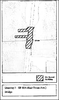
990(i) SR 804 (East Ocean Ave.) Bridge – An Idle Speed No Wake zone from shoreline to shoreline, in and adjacent to the Florida Intracoastal Waterway, bounded on the north by a line drawn perpendicular to the centerline of the Florida Intracoastal Waterway 575 feet north of the north end of the fender of the SR 804 (East Ocean Ave.) Bridge, and bounded on the south by a line drawn perpendicular to the centerline of the Florida Intracoastal Waterway 300 feet south of the south end of the bridge fender, as depicted in drawing I.
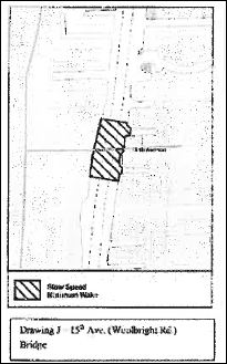
1085(j) 15th Ave. (Woolbright Rd.) Bridge – A Slow Speed Minimum Wake zone from shoreline to shoreline, in and adjacent to the Florida Intracoastal Waterway, bounded on the north by a line drawn perpendicular to the centerline of the Florida Intracoastal Waterway 300 feet north of the north end of the fender of the 15th Avenue (Woolbright Rd.) Bridge, and bounded on the south by a line drawn perpendicular to the centerline of the Florida Intracoastal Waterway 300 feet south of the south end of the bridge fender, as depicted in drawing J.
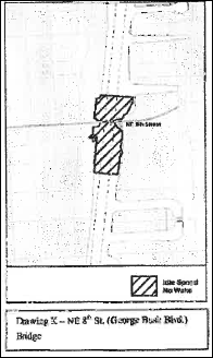
1178(k) N.E. 8th Street (George Bush Blvd.) Bridge – An Idle Speed No Wake zone from shoreline to shoreline, in and adjacent to the Florida Intracoastal Waterway, bounded on the north by a line drawn perpendicular to the centerline of the Florida Intracoastal Waterway 300 feet north of the north end of the fender of the N.E. 8th Street (George Bush Blvd.) Bridge, and bounded on the south by a line drawn perpendicular to the centerline of the Florida Intracoastal Waterway 600 feet south of the south end of the bridge fender, as depicted in drawing K.
1275(l) SR 806 (East Atlantic Ave.) Bridge – A Slow Speed Minimum Wake zone from shoreline to shoreline, in and adjacent to the Florida Intracoastal Waterway, bounded on the north by a line drawn perpendicular to the centerline of the Florida Intracoastal Waterway 675 feet north of the north end of the fender of the SR 806 (East Atlantic Ave.) Bridge, and bounded on the south by a line drawn perpendicular to the centerline of the Florida Intracoastal Waterway, 500 feet north of the centerline of the Knowles Park boat ramp, as depicted in drawing L.
1371(m) Knowles Park Boat Ramp – An Idle Speed No Wake zone from shoreline to shoreline, in and adjacent to the Florida Intracoastal Waterway, bounded on the north by a line drawn perpendicular to the centerline of the Florida Intracoastal Waterway, 500 feet north of the centerline of the Knowles Park boat ramp, and bounded on the south by a line drawn perpendicular to the centerline of the Florida Intracoastal Waterway 300 feet north of the north end of the fender of the 12th Street (Linton Blvd.) Bridge, as depicted in drawing M.
1464(n) 12th Street (Linton Blvd.) Bridge – A Slow Speed Minimum Wake zone from shoreline to shoreline, in and adjacent to the Florida Intracoastal Waterway, bounded on the north by a line drawn perpendicular to the centerline of the Florida Intracoastal Waterway 300 feet north of the north end of fender of the 12th Street (Linton Blvd.) Bridge, and bounded on the south by a line drawn perpendicular to the centerline of the Florida Intracoastal Waterway 300 feet south of the south end of the bridge fender, as depicted in drawing N.
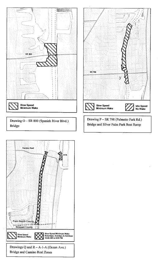
1556(o) SR 800 (Spanish River Blvd.) Bridge – A Slow Speed Minimum Wake zone from shoreline to shoreline, in and adjacent to the Florida Intracoastal Waterway, bounded on the north by a line drawn perpendicular to the centerline of the Florida Intracoastal Waterway 300 feet north of the north end of the fender of the SR 800 (Spanish River Blvd.) Bridge, and bounded on the south by a line drawn perpendicular to the centerline of the Florida Intracoastal Waterway 300 feet south of the south end of the bridge fender, as depicted in drawing O.
1651(p) SR 798 (Palmetto Park Rd.) Bridge and Silver Palm Park Boat Ramp Zones
16651. Lake Wyman Vicinity to SR 798 (Palmetto Park Rd.) Bridge – A Slow Speed Minimum Wake zone from shoreline to shoreline, in and adjacent to the Florida Intracoastal Waterway, in the vicinity of marker 63 (which is in the southern portion of Lake Wyman), and bounded on the south by a line drawn perpendicular to the centerline of the Florida Intracoastal Waterway 300 feet north of the northern end of the fender system of the SR 798 (Palmetto Park Rd.) Bridge, as depicted in drawing P.
17522. Silver Palm Park Boat Ramp and SR 798 Bridge – An Idle Speed No Wake zone from shoreline to shoreline, in and adjacent to the Florida Intracoastal Waterway, bounded on the north by a line drawn perpendicular to the centerline of the Florida Intracoastal Waterway 300 feet north of the north end of the fender of the SR 798 (Palmetto Park Rd.) Bridge, and bounded on the south by a line drawn perpendicular to the centerline of the Florida Intracoastal Waterway 500 feet south of the centerline of the Silver Palm Park boat ramp, as depicted in drawing P.
1852(q) A-1-A (Ocean Ave). Bridge – A Slow Speed Minimum Wake zone from shoreline to shoreline, in the Boca Raton Inlet, bounded on the northwest by a line drawn perpendicular to the centerline of the channel 300 feet northwest of the northwest end of the fender of the A-1-A (Ocean Ave.) Bridge, and bounded on the south by a line drawn perpendicular to the centerline of the channel 300 feet south of the south end of the bridge fender, as depicted in drawing Q.
1936(r) Camino Real Zones –
19411. Camino Real Bridge – A Slow Speed Minimum Wake zone from shoreline to shoreline, in and adjacent to the Florida Intracoastal Waterway, bounded on the north by a line drawn perpendicular to the centerline of the Florida Intracoastal Waterway 300 feet north of the north end of the fender of the Camino Real Bridge, and bounded on the south by a line drawn perpendicular to the centerline of the Florida Intracoastal Waterway 300 feet south of the south end of the bridge fender, as depicted in drawing R.
20302. Camino Real Bridge to Palm Beach-Broward County Line – A Slow Speed Minimum Wake zone to be in effect from 10:00 a.m. to 6:00 p.m. on Saturdays, Sundays, and Holidays, in and adjacent to the Florida Intracoastal Waterway, bounded on the north by a line drawn perpendicular to the centerline of the Florida Intracoastal Waterway 300 feet south of the south end of the fender of the Camino Real Bridge, and bounded on the south by the Palm Beach-Broward County Line, as depicted in drawing R.
2117(2) The boating restricted areas described in Rule 212568D-24.017, 2126F.A.C., are depicted on the following drawings:


2133Rulemaking Authority 2135327.04, 2136327.46 FS. 2138Law Implemented 2140327.46 FS. 2142History–New 2-28-91, Amended 8-6-92, 6-14-93, Formerly 16N-24.017, Amended 10-27-97, 3-3-99, Formerly 62N-24.017, Amended 5-20-10, 4-6-15.


